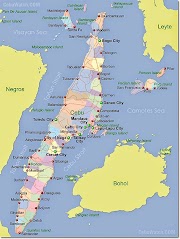
December 30, 2014: Seniang made landfall in Cebu early morning of Tuesday that brought huge damages in southern part of Cebu.
Typhoon Seniang Destruction in Visayas and Mindanao - Photos, Video
For Tropical Storm “#SeniangPH” (JANGMI)
Issued at 5:00 AM, 30 DECEMBER 2014
• Estimated rainfall amount is from 7.5 – 15 mm per hour (moderate - heavy) within the 300 km diameter of the Tropical Storm.
• Residents in low lying and mountainous areas of the provinces with PSWS#2 and PSWS#1 are alerted against possible flashfloods and landslides.
• Ocean waves may reach up to 5 meters.
• Fisherfolks and those with small seacrafts are advised not to venture out over the seaboards of northern and central Luzon and
the eastern seaboard of southern Luzon, seaboards of Visayas and
over the northern and eastern seaboards of Mindanao.
• The public and the disaster risk reduction and management council concerned are advised to take appropriate actions and watch for the next bulletin to be issued at 11AM today.
Location of eye/center: At 4:00 AM today, the center of Tropical
Storm “SENIANG” was estimated based on all available data
including Cebu Doppler radar at 35 km Southeast of Mactan, Cebu
(9.9°N, 123.7°E).
Strength: Forecast to move West Northwest at 11 kph.
Forecast Positions:
• 24 hour (Tomorrow morning): 235 km West Northwest of Dumaguete City.
• 48 hour (Thursday morning): 115 km South Southwest of Puerto Princesa City.
• 72 hour (Friday morning): 450 km Southwest of Puerto Princesa
City.
PUBLIC STORM WARNING SIGNAL
PSWS#2(Winds of 61-100 kph is expected in at least 24 hrs)
Visayas: Bohol, Siquijor, Cebu, Guimaras, Negros Oriental and
Negros Occidental.
Impacts of the wind
• Rice and corn maybe adversely affected
• Few large trees uprooted
• Large number of nipa and cogon houses partially or totally
unroofed and old galvanized iron roofs may roll off.
• Billboards/Signage may roll off
• Travel by all types of sea vessels and aircrafts are risky
These areas will have stormy weather with heavy to intense rains.
Residents in low lying and mountainous areas are alerted against
possible flashfloods and landslides.
PSWS#1(Winds of 30-60 kph is expected in at least 36 hrs)
Visayas: Leyte, Southern Leyte, Camotes Island, Iloilo, Antique, Capiz and Aklan.
Mindanao: Camiguin, Surigao del Norte, Agusan del Norte, Misamis
Occidental, Misamis Oriental and Zamboanga del Norte.
Impacts of the wind
• Twigs and branches of trees maybe broken
• Some banana plants may tilt or land flat on the ground
• Rice in flowering stage may suffer significant damage
• Some nipa and cogon houses maybe partially unroofed
• Sea travel of small sea crafts and fishing boats is risky
These areas will have moderate to heavy rains with occasional gusty winds. Residents in low lying and mountainous areas are alerted against possible flashfloods and landslides.
•The public and the disaster coordinating councils concerned are advised to take appropriate actions and watch for the next weather
bulletin to be issued at 5 AM today.


0 Comments